
- Weather
- Latest Forecast
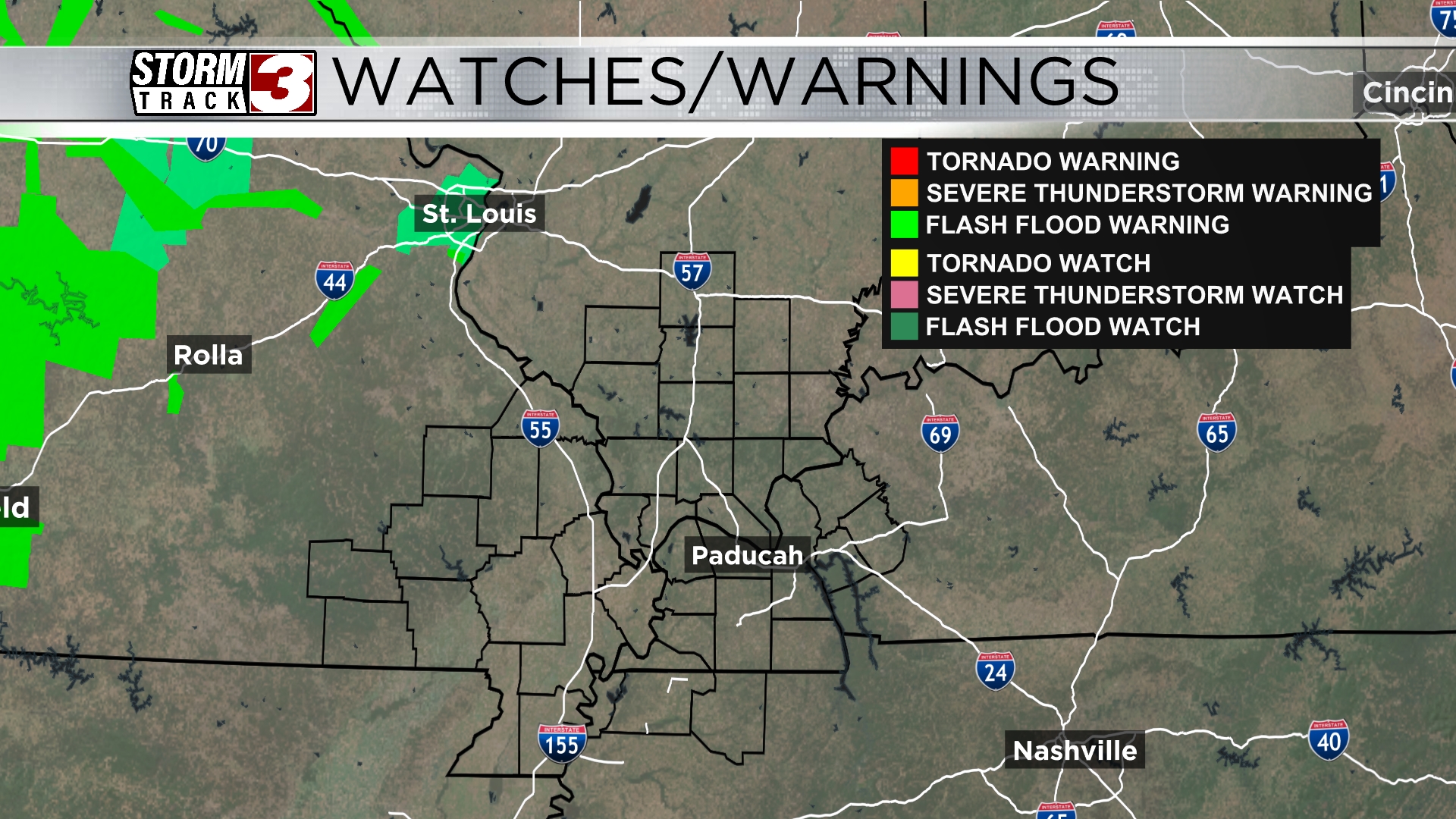
- Radar
- Weather Cameras
StormTrack 3 Always Tracking
Right Now
- Humidity: 95%
- Cloud Coverage:72%
- Wind: 4 mph
- UV Index: 8 Very High
- Sunrise: 05:33:43 AM
- Sunset: 08:20:17 PM
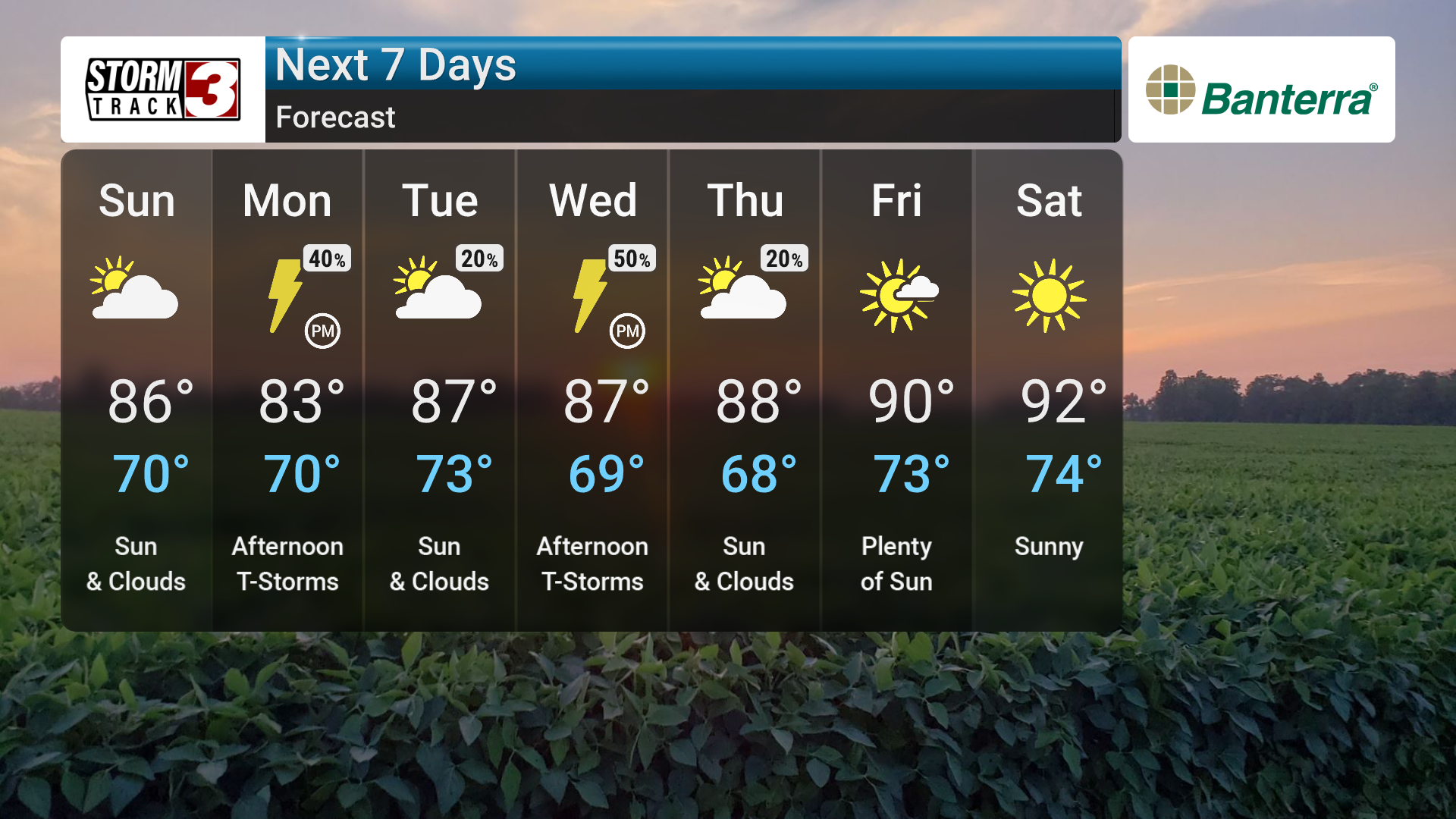
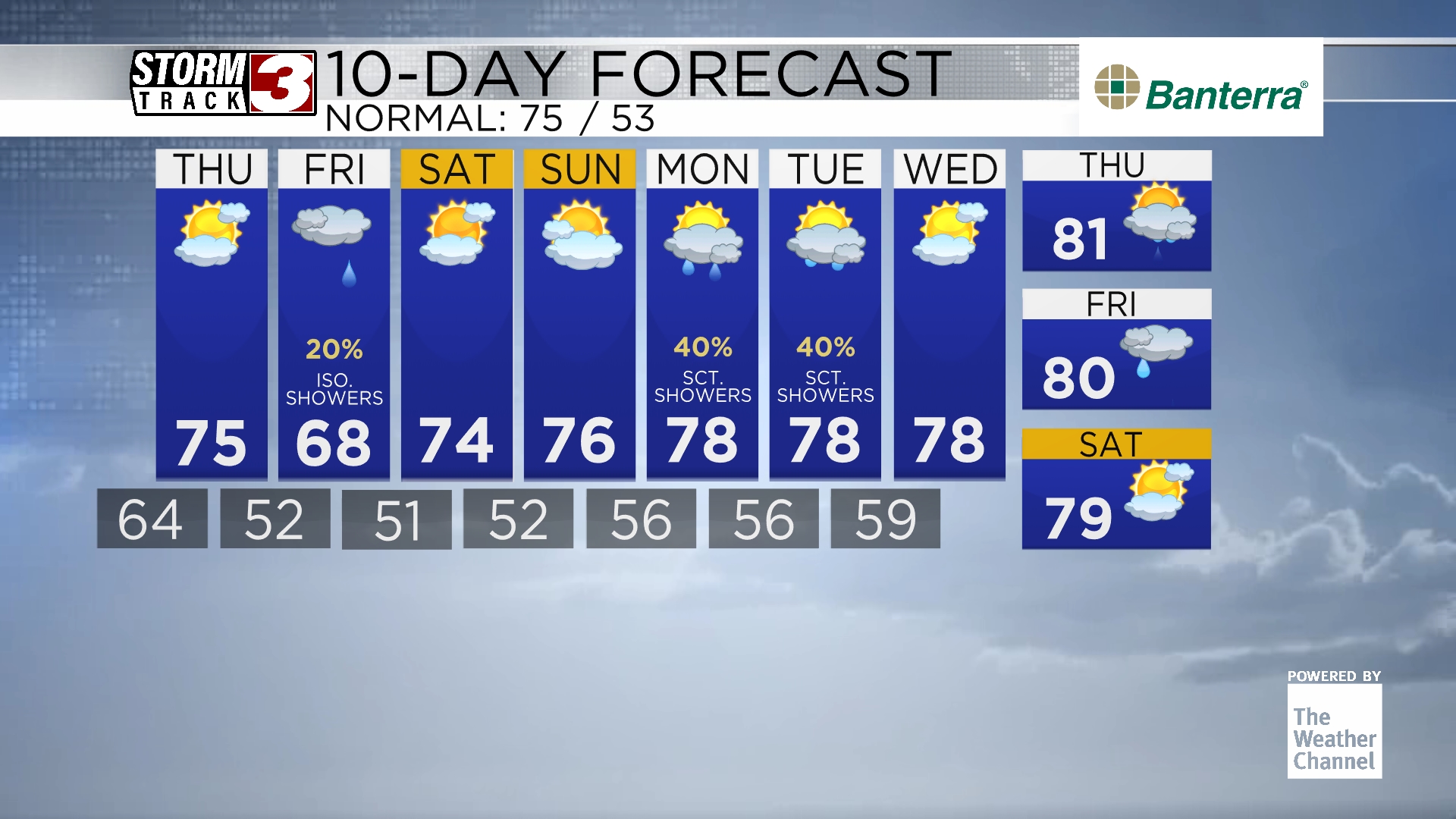
Going forward, we can anticipate a continued pattern of daily shower and thunderstorm chances throughout much of the upcoming week. Elevated humidity levels will persist, and temperatures will gradually warm, reaching into the upper 80s by mid-week.
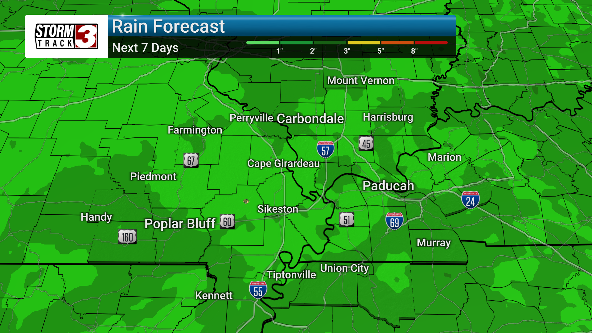
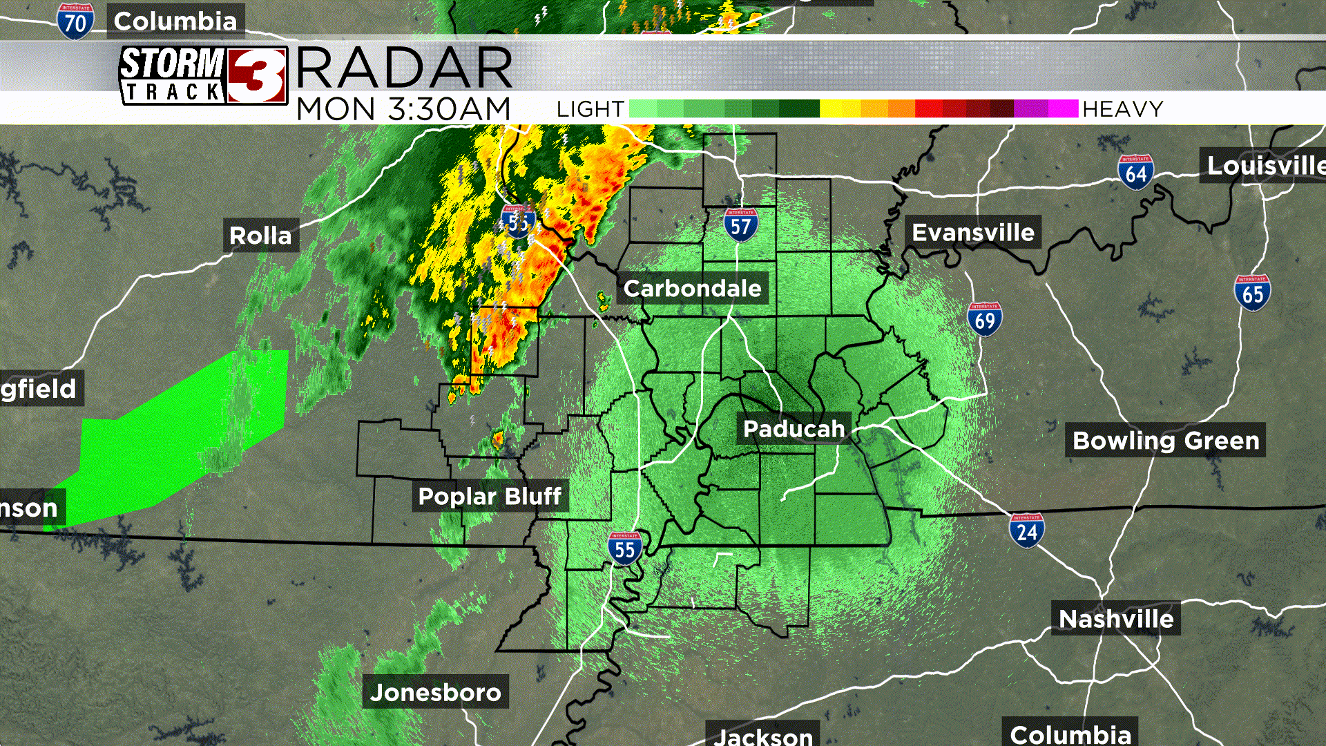
There will be a couple of distinct periods where showers and storms are expected to be more concentrated. The first will occur through this evening; however, the coverage of showers/storms should diminish greatly after sunset. The next best chance for widespread showers and storms will be from Sunday night into Monday PM, as another shortwave system moves through the region.
Heavy rainfall is the main concern with these storms, with some areas potentially receiving 1.5-2 inches of rain. This heavy rain could lead to localized flooding, especially in areas with slow-moving storms.
Otherwise, temps stay pretty uniform with highs in the 80s and lows near 70 with high humidity.
As we head towards next weekend, a ridge may bring even warmer and more humid conditions. Temperatures could reach the low 90s by next weekend, with heat index values pushing into the mid-90s.
Hourly Forecast
Carterville, IL
Wind: N @ 2mph
Precip: 4% Chance
Humidity: 95%
Wind Chill: 70°
Heat Index: 70°
UV Index: 0 Low
Visibility: 2.1 mi
Wind: NNE @ 2mph
Precip: 4% Chance
Humidity: 94%
Wind Chill: 70°
Heat Index: 70°
UV Index: 0 Low
Visibility: 2.6 mi
Wind: NNE @ 3mph
Precip: 4% Chance
Humidity: 94%
Wind Chill: 71°
Heat Index: 71°
UV Index: 0 Low
Visibility: 4 mi
Wind: NE @ 3mph
Precip: 4% Chance
Humidity: 91%
Wind Chill: 72°
Heat Index: 72°
UV Index: 1 Low
Visibility: 10 mi
Wind: NNE @ 4mph
Precip: 3% Chance
Humidity: 87%
Wind Chill: 74°
Heat Index: 74°
UV Index: 3 Moderate
Visibility: 10 mi
Wind: N @ 3mph
Precip: 3% Chance
Humidity: 80%
Wind Chill: 76°
Heat Index: 76°
UV Index: 5 Moderate
Visibility: 10 mi
Wind: NW @ 3mph
Precip: 4% Chance
Humidity: 75%
Wind Chill: 78°
Heat Index: 78°
UV Index: 6 High
Visibility: 10 mi
Wind: NW @ 4mph
Precip: 10% Chance
Humidity: 70%
Wind Chill: 80°
Heat Index: 84°
UV Index: 7 High
Visibility: 10 mi
Wind: NW @ 5mph
Precip: 8% Chance
Humidity: 67%
Wind Chill: 81°
Heat Index: 85°
UV Index: 8 Very High
Visibility: 10 mi
Wind: NW @ 6mph
Precip: 4% Chance
Humidity: 66%
Wind Chill: 82°
Heat Index: 86°
UV Index: 7 High
Visibility: 10 mi
Wind: NNW @ 6mph
Precip: 2% Chance
Humidity: 64%
Wind Chill: 82°
Heat Index: 87°
UV Index: 7 High
Visibility: 10 mi
Wind: N @ 6mph
Precip: 2% Chance
Humidity: 63%
Wind Chill: 83°
Heat Index: 87°
UV Index: 5 Moderate
Visibility: 10 mi
7-Day Forecast
Carterville, IL
Chance of Precip: 9%
Sunrise: 05:33:43 AM
Sunset: 08:20:17 PM
Humidity: 77%
Wind: N @ 6mph
UV Index: 8 Very High
Sunday Night
Mostly cloudy skies early then periods of showers late. Low near 70F. Winds light and variable. Chance of rain 60%.
Chance of Precip: 70%
Sunrise: 05:33:47 AM
Sunset: 08:20:38 PM
Humidity: 88%
Wind: ESE @ 6mph
UV Index: 4 Moderate
Monday Night
Cloudy. Low 69F. Winds light and variable.
Chance of Precip: 22%
Sunrise: 05:33:53 AM
Sunset: 08:20:57 PM
Humidity: 74%
Wind: SW @ 9mph
UV Index: 9 Very High
Tuesday Night
Mostly clear during the evening followed by cloudy skies overnight. Low 73F. Winds SSW at 5 to 10 mph.
Chance of Precip: 40%
Sunrise: 05:34:01 AM
Sunset: 08:21:14 PM
Humidity: 75%
Wind: SSW @ 16mph
UV Index: 10 Very High
Wednesday Night
Variable clouds with scattered thunderstorms. Low 69F. Winds SW at 10 to 15 mph. Chance of rain 50%.
Chance of Precip: 24%
Sunrise: 05:34:11 AM
Sunset: 08:21:30 PM
Humidity: 71%
Wind: WNW @ 8mph
UV Index: 10 Very High
Thursday Night
Clear. Low 68F. Winds light and variable.
Chance of Precip: 9%
Sunrise: 05:34:22 AM
Sunset: 08:21:44 PM
Humidity: 68%
Wind: S @ 9mph
UV Index: 10 Very High
Friday Night
Clear skies. Low 73F. Winds S at 5 to 10 mph.
Chance of Precip: 7%
Sunrise: 05:34:35 AM
Sunset: 08:21:56 PM
Humidity: 67%
Wind: SSW @ 12mph
UV Index: 10 Very High
Saturday Night
A mostly clear sky. Low 74F. Winds SSW at 5 to 10 mph.