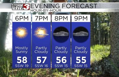


WSIL(Carterville, Ill) -- This evening, most of us are are seeing temperatures that are more seasonable for this time of year. Most places are reporting temperatures that are in the low to mid 60s, under mostly cloudy to overcast skies. Winds are out of the southwest at 15 to 25 miles per hour. Due to the gusty winds, warm temperatures, and relatively dry air, there is a Red Flag warning in place for all of southern Illinois west of interstate 57 and southeastern Missouri until 7 PM. So, outdoor burning this evening should be avoided.
This evening, skies will continue to be overcast, and winds will be out of the southwest at 15 to 25 miles per hour, gusting to 30 miles per hour. Temperatures will hold in the upper 5s to low 60s, but once the sun sets, temperatures will drop into the mid 40s. Overnight, skies will clear, and be mostly sunny to kick off Saturday. Morning lows tomorrow will be in the low 40s.聽
Mostly sunny skies are expected for tomorrow, and that sunshine will stick around for most of the day tomorrow. Temperatures for highs tomorrow will reach the lower to mid 60s once again. Cloud cover will enter the region late in the evening into the overnight hours Saturday. While a few isolated showers are possible late tomorrow evening, the better rain and storm chances do arrive in the early morning hours Sunday, and off and on showers and thunderstorms are likely all day Sunday.聽
Temperatures for Sunday will reach the mid 60s, and the mid to upper 60s will stick around for next week.聽