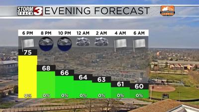


WSIL(Carterville, Ill) -- This evening we are tracking lots of sunshine across the area with temperatures that are sitting in the mid 70s areawide. Winds are also quite strong, out of the south at 20 to 30 miles per hour. Additionally, we are tracking a Red Flag Warning for Carter, Ripley, Wayne, and Madison counties until 8PM. Just because the rest of the region is not included in the Red Flag Warning does not mean that there isn't a fire risk areawide. Extreme caution should be used if outdoor burning is necessary.
This evening, you can expect to see temperatures in the low to mid 60s for the majority of the evening, and dip into the upper 50s for morning lows tomorrow. Skies tomorrow morning will be mostly cloudy. At 8AM, a Wind Advisory will go into effect and be in place until 8 in the evening. Winds tomorrow will be quite gusty, potentially as high as 50 miles per hour.
Temperatures tomorrow will warm into the low to mid 70s for highs. This, combined with windy conditions, and low relative humidity, will lead to elevated fire potential tomorrow afternoon. We are also tracking the potential for isolated to scattered storms that will impact the region in the afternoon and evening. The better storm chances will be east of interstate 57, and there is a risk of a few storms being on the strongside, but this chance is very low as there will not be very much moisture in place.
A cold front will sweep through and bring colder conditions to the region for Thursday, the first day of spring. Highs will only be in the mid up upper 50s.