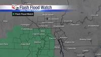


CARTERVILLE (WSIL) �� A Flash Flood Watch is in effect for southeast Missouri, southwest Illinois, and parts of western Kentucky until 7 p.m. Tuesday.
The remnants of Hurricane Barry will work north and east through the first half of the work week. Widespread rain is expected throughout the day Monday with the heaviest falling in southeast Missouri.
As the system draws closer, winds will pick up from the southeast Monday afternoon with gusts over 20 miles per hour possible. A strong storm or two will also be possible Monday afternoon with brief spin up tornadoes and damaging winds as the main threats.
Once the sun goes down, rain and storms will begin to decrease, but there’s more scattered showers and storms associated with the remnants of Barry on the way for Tuesday.
Once the rain moves out by midweek, the heat and humidity is set to return. Late this week will feature afternoon temperatures in the low to mid 90s with heat index values well into the triple digits.
Meteorologist Nick Hausen has the latest on the work week forecast on News 3 This Morning.