


WSIL (Carterville) -- It's been a misty, cloudy and chilly afternoon across the region thanks to a cold front that moved through the region. We hit our highs for today around sunrise since the temperatures have dropped drastically from the front.
We'll be somewhere around the upper 30s, lower 40s for most of us (excluding Western Kentucky). Overnight we'll fall into the upper 20s.

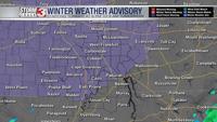
Tonight is still the big story with the chance of freezing drizzle likely. The big focus won't really be the amount, which is expected to be between a glaze and a tenth of an inch, but more so the impacts.
Especially along and West of I-57 and SEMO will see slick roads, bridges and overpasses. Further East will be mostly cold rain. Based off of the expected impacts, a Winter Weather Advisory was issued beginning tonight at 6 PM and lasting until 9 AM tomorrow.

We'll get a quick break from precipitation during the day Monday before the chance returns tomorrow night. The colder air will stay further south with this second round. Likely Southern Illinois will see sleet and snow while Western Kentucky and the Bootheel will have more freezing rain.
Similar with tonight's system, we'll still focusing more on travel impacts over accumulation totals. If you have plans tomorrow night or early tomorrow morning, take extra caution.

Once we get through tomorrow's system we still aren't out of the woods are far as winter precipitation goes. Another, more scattered than widespread, chance is possible Tuesday evening. We'll be finishing the work week with cold rain off to our south.
To everyone excited for Spring, let's hope Punxsutawney Phil has good news for us on Thursday.