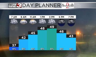


WSIL(Carterville, Ill.) -- This morning, temperatures are still on the chilly side, with most locations seeing the upper 30s and lower 40s. Winds are at least more clam, sustained out of the northwest at 5 to 10 miles per hour. Skies are partly cloudy.
Today, we will see mostly cloudy skies all day, but a few breaks are possible this morning. Through the midday hours, temperatures should only be in the lower 40s; highs today will be in the upper 40s for most of us, and a few locations could see the lower 50s in pars of the bootheel and western Kentucky.
Winds will be out of the north west at 10 to 15 miles per hour, gusting to 20 miles per hour. Overnight tonight, we will see cloudy skies, and cloudy skies are expected for tomorrow morning. Moning lows tomorrow will be in the mid 30s.
A high pressure system will move just south of the area tomorrow and we will see more sun in the afternoon. Highs should be in the lower 50s, with winds will be mostly calm at 5-10 miles per hour.
Sunday morning's lows should be in the lower 40s, and high temperatures will return to the 60s. This is due to southerly winds that will be at 10 to 15 miles per hour. The 60s will stick around for Monday, but another cold front will move through Monday into Tuesday, and it will send temperatures back the the mid 40s for high temperatures by Tuesday. Colder weather is expected for the rest of the week, as well as rain chances Wednesday and Thursday.