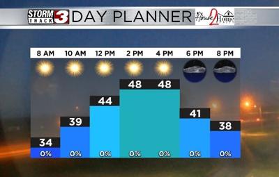


WSIL(Carterville, Ill.) -- This morning, temperatures are much colder than this time yesterday; as much as 30 degrees colder in southern Illinois. Skies are mostly clear, and winds are out of the north and west at 5 to 10 miles per hour. This is causing windchill values to linger in the mid 20s for some of us this morning.
Today, you can expect to see below average temperatures last through most of the day. Temperatures should linger into the upper 30s and lower 40 for the midday hours. High temperatures today will be in the mid to upper 40s. Winds today should be mostly calm as a high pressure system will be over us for most of the day. This will also help skies today stay mostly sunny for most of the day, but a few passing clouds are possible this afternoon.
Overnight, the area of high pressure will move east, and skies will be partly cloudy by 10PM. Overcast skies are expected by tomorrow morning. Morning lows tomorrow will be in the upper 30s, and temperatures tomorrow afternoon will reach the lower 50s for afternoon highs.
Tomorrow, a disturbance will move through the region during the afternoon. Conditions will remain dry, until lunchtime, but rain chances will be on the increase for the afternoon and evening. Rain showers will be light, and showers will stick around through most of the evening and through early Thursday morning. But, by 8 or 9 AM Thursday, we will see dry conditions.
Cloud cover will linger through the lunchtime hour Thursday, but sunshine is expected later in the day. Temperatures will be much cooler for Thursday, likely only reaching the lower 40s for highs. Colder weather is expected to enter the region for the weekend, with highs only reaching the lower 30s Saturday and Sunday.