


WSIL(Carterville, Ill.)-- This morning, temperatures are on the chilly side. Temperatures in southern Illinois are in the lower to mid 40s this morning. It is slightly warmer further south across southeastern Missouri and western Kentucky where temperatures are in the upper 40s.
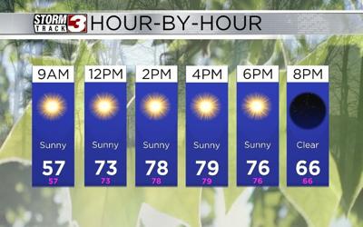
Today, you can expect similar conditions to the last few days across the area. Temperatures for the morning will be in the 40s through 8AM. We will see the lower 70s by 12PM, and highs today will be in the upper 70s and lower 80s areawide. Humidity levels this afternoon will remain quite pleasant, with dew points running around 40. The low relative humidity, warm temperatures, and dry conditions will lead to elevated fire potential this afternoon.
Skies will be mostly sunny all day, and wilds will be variable at 5 to 10 miles per hour. Overnight tonight, you can expect to mostly clear skies. This will help us to cool once again into the upper 40s and lower 50s.
Sunny skies will last all day tomorrow as well. High temperatures will be a bit warmer tomorrow than they have been. Temperatures will warm into the mid to upper 80s areas wide tomorrow. Low relative humidity values, between 20 and 30 recent, will linger tomorrow, so elevated fire potential will be a concern.
The 90s are expected for Wednesday, but a major change up to the pattern is expected for the second half of the work week, as a tropical system could move over the region late Thursday night through Friday morning. This is still several days put, so the track will likely change, but it is definitely something to watch.