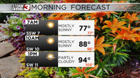

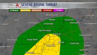


CARTERVILLE (WSIL) -- It has been a very soggy day especially across southern Illinois. Widespread rain and the chance for storms will continue through the evening. Some of the storms could be strong to severe.
The best chance for severe storms lies through the southern half of the region. In parts of western Kentucky, southeast Missouri and northwest Tennessee.
Overall the severe threat is low. However, damaging wind gusts and a brief spin up tornado can't be ruled out. Be sure to stay weather aware. Timing for the stronger storms looks to be between 5 PM and 10 PM.
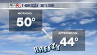
The rain and storms should move east of the region around midnight, bringing back the drier weather by Thursday.

High temperatures Thursday will occur just after midnight, up in the low 50s. As the cooler settles in, temperatures will then drop into the 40s by the afternoon. It will also be a breezy day with winds out of the west, gusting near 35 mph.