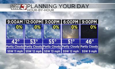
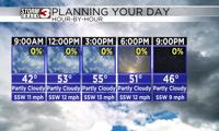


WSIL (Carterville, Ill.) -- This morning, we are tracking temperatures that are well above normal for this time of year. For the most part, we are seeing temperatures in the mid to upper 30s, with mostly clear skies, and south-southwesterly winds at 5 to 10 miles per hour.
Today, you can expect to see temperatures warm into the mid to upper 40s by the midday hours and into the mid to upper 50s for afternoon highs. Areas in southeastern Missouri should see warmer highs, potentially in the low 60s. Skies today will be partly to mostly cloudy. However, these clouds will remain fairly high level, so they shouldn't completely obscure the sunshine. Winds will be on the breezy side, at 10 to 15 miles per hour, with gusts potentially as high as 20 to miles per hour.
Overnight, we are tracking conditions that will be mostly clear. Winds will calm, and morning lows will be in the mid to upper 30s. Highs tomorrow will likely reach the low to mid 60s across most of the area, with mostly sunny skies. WInds tomorrow will be mostly calm.
While the warmer conditions are expected to last through the entire week, dry and sunny conditions will not. We are tracking rain chances that will be on the increase as we head into Wednesday. Scattered showers are expected especially in the evening, and we could even see a few imbedded thunderstorms.
Once these showers move out, dry conditions will persist through the remainder of the work week.