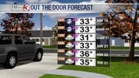

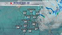


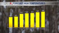


WSIL (Carterville) -- It's a bitter cold start to the day with temperatures as you're stepping out the door falling below freezing. Wind chills will stay steady below our temperatures all day. Conditions will feel more like the mid 20s despite highs in the upper 30s.

A few snow flurries are possible for southern Illinois and western Kentucky mid-morning, but no major impacts are expected. Hopefully this helps scratch that snow lovers itch because we aren't tracking more snow any thing time.

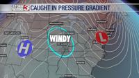
It's also incredibly windy today thanks to a tight pressure gradient. The nor'easter we've been keeping an eye on is now off the coast of the mid-Atlantic. There's a high pressure over the Plains trying to build in. We're caught in between both systems, leading to winds gusts above 30 mph today.
Tomorrow morning will continue the bitter cold trend with temperatures in the upper teens, but after that, we'll see warm temperatures return.

Midweek ushers in above average temperatures as we're tracking the mid 50s. Rain chances return Friday and will off & on throughout the following week. Looking more like a soggy, and not a white Christmas.