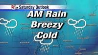


WSIL (Carterville) -- Another gray and damp day for us as the low pressure continues moving well off to our northeast. We're seeing wrap around rain coming off the low so a few isolated showers can't be ruled out this evening.
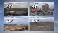
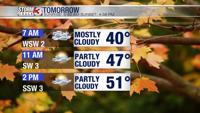
Temperatures are close to average for this time of the year with highs in the upper 40s, lower 50s.

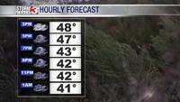
Into tonight temperatures are remaining mild in 40s and the overcast skies are sticking with us.

We're starting the week on a quiet note. Mild temperatures and clearing skies are all we're tracking. Winds should also calm down a bit. Clouds will build back in before the next system.

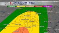
Tuesday is the day to watch this week for our next chance of showers and storms. A well defined front will move through Tuesday evening bringing a decent chance of severe weather to our south over the lower Mississippi Valley. The question is how far north this severe weather will push.
Most of our region is in Slight Risk (2 out of 5) chance for something severe. Our northern most counties are under a Marginal Risk (1 out of 5) and southern most under an Enhanced Risk (3 out of 5).
Make sure to have the Storm Track 3 app and other ways to get alerts for this system, especially with it being an overnight event.

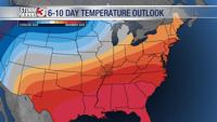
Looking ahead to the rest of the week and beyond, our 6 to 10 day temperature outlook is trending very warm.