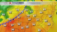


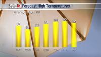


Carterville (WSIL) -- Today will be one of the warmest days we'll see for a while as highs are expected to be in the mid to upper 90s. Humidity will also be higher today as well. Mostly clear skies are expected but we'll see them build overnight.

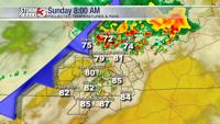
Beginning around midnight, there will be an isolated chance for showers and storms. Chances will increase slightly more into the early morning hours as a cold front moves into the region.

If you have any outdoor plans tomorrow, stay weather aware because we could see some pockets of heavy rain with this system. The chance of showers sticks around until the evening. Tomorrow will be about 10 degrees cooler with highs in the mid to upper 80s.

The "cool" pattern will continue through the beginning of the next work week with highs consistently being in the 80s. After tomorrow, we won't see another chance of rain until Friday.