


CARTERVILLE (WSIL) -- Happy first day of summer. It hasn't been a bad start to the season. Temperatures are running in the low to mid 80s this afternoon, with partly cloudy skies. It's just a bit humid.
An isolated storm or two can't be ruled out through the evening, primarily through the eastern half of the region. Brief heavy rain and lightning will be possible, but no severe weather is expected. Most will stay dry.
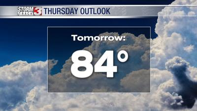
The upper-level low that has kept the spotty rain chances around for the last few days will stick around through Thursday. Thursday will be very similar to today. High temperatures will climb back into the low to mid 80s, with more small storm chances.
A pattern change will begin by the end of the week, bringing back the heat and humidity in full force. By the weekend high temperatures will climb back into the low to mid 90s, with heat indices nearing the triple digits.
The entire viewing is still abnormally dry. The next decent signal for rain will arrive by Sunday, along a cold front. A few strong storms will also be possible.