


Carterville (WSIL) -- The heat has arrived to the region as we've already hit the low to mid 90s this afternoon. Today is just the start of a very hot week. The heat advisory that was issued for today, was extended through Wednesday at 8 PM.

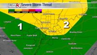
The other threat we're tracking is a possible isolated storm. The Storm Prediction Center has southern Illinois, parts of southeastern Missouri and western Kentucky under a slight (2 out of 5) risk for severe weather, with the rest of us under a marginal (1 out of 5) threat.
The confidence for these storms are low due to a strong cap (a layer of warm air aloft, which suppresses thunderstorms), that's covering most of our region. There is a slight possibility if any of these storms can form that we could see large hail, damaging winds and a possible tornado but it is unlikely.

The heat wave is sticking around for the work week as temperatures climb into the mid to upper 90s and heat indices even higher. If you can, limit your time outside, make sure to stay hydrated, and stay weather aware.

The above average temperatures will remain for the immediate future in our 7 and 10 day forecast. After tonight, rain won't return to the region until Thursday, and for now it looks very isolated.
Stay cool and download the Storm Track 3 app!