
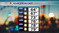


WSIL(Carterville, IL)--This morning, we are starting slightly warmer this morning when compared to yesterday morning, with lows in the low to mid 60s. However, after the passage of the cold front, things today will be cooler than they were yesterday afternoon with highs today only being around the 80 degree mark, give or take a few degrees depending on location.

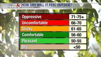
Humidity will again be low with dewpoints only in the mid 50s.

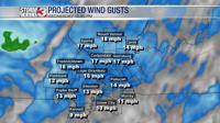
This afternoon will be breezy with wind gusts around 15 to 20 miles per hour this afternoon. Winds will calm later this evening, and temperatures will be in the low to mid 50s to start the morning tomorrow.
Tomorrow will again be mild with highs in the upper 70s to near 80 in the southern parts of the region. We will retain the low dewpoints in the 50s again, but winds will be calmer.

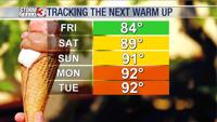
Tomorrow and Friday will likely be the last days of mild weather, because we are tracking our next warm up which will start on Saturday with highs in the mid to upper 80s, before reaching the low to mid 90s next week.
Things will remain dry through Saturday before rain chances increase for Sunday. We could see isolated to scattered storm chances next week