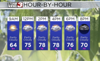


WSIL(Carterville, Ill.)-- This morning, it is feeling very mild and fall like for the entire region. Most locations are seeing temperatures in the upper 50s, but a few areas are still hanging onto the lower 60s in southeastern Missouri and western Kentucky. Skies this morning are partly cloudy across the area.
As we go through Tuesday, skies will become mostly cloudy later this morning, and remain mostly cloudy though the afternoon and evening. Cloud cover will help keep us cool once again this afternoon. Temperatures by midday will be in the lower 70s, and highs across most of southern Illinois will be in the upper 70s to near 80. Lower 80s are expected further south.
Dew points this afternoon will be in the lower 50s and upper 40s. This, combined with breezy winds of 10 to 15 miles per hour, will create an elevated fire risk.
Despite mostly cloudy skies, we should remain free of any showers, until late this evening, after 10PM. Overnight, isolated showers and a few rumbles of thunder are expected for our far southern counties in the bootheel of Missouri and western Kentucky.
Isolated showers are expected for most of the day tomorrow for our far southern counties in the bootheel of Missouri and western Kentucky. We should remain mostly dry across southern Illinois.
Morning lows tomorrow should be a few degrees warmer in the lower 60s and highs should reach the mid 80s. The upper 80s are expected for Thursday. The mid 80s are expected for Friday with a chance of scattered showers and storms as a cold front pushed into the area.
This front will take us from the mid 80s for highs to the low to mid 70s for highs for the weekend, and morning lows could be in the lower 50s and upper 40s.