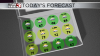


WSIL(Carterville, Ill.)-- This morning, a lot of us are waking up to temperatures that are much warmer than yesterday. We are seeing the upper 40s and lower 50s.
Today we will see temperatures warm into the upper 60s by lunchtime, and highs that will be in the lower 70s. Ahead of a weak cold front that will move through overnight, we could see winds become breezy this afternoon, with peak wind gusts expected to be around 30 miles per hour.

This cold front will cause scattered showers and thunderstorms to form, and they will track northwest to southeast. Showers should be light and cause at most a quarter inch of rainfall.
The cold front will cause slightly cooler lows tomorrow morning, mainly in the northernmost counties. Lows could be in the lower 40s. Highs tomorrow will also be slightly cooler than today, likely topping out in the upper 60s and lower 70s.
Mild weather will last through Thursday, but a few disturbances will bring storm chances Friday through the weekend.