


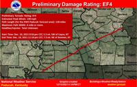


(WSIL) -- After several days of extensive surveying, the National Weather Service in Paducah, KY has determined a preliminary EF-4 tornado moved from Fulton County to Muhlenberg County.
The tornado is being rated an EF-4 with estimated peak winds of 190 mph. The twister traveled 128 miles and the storm was a mile or more wide.

The tornado started at 8:56 p.m. five and a half miles southwest of Cayce, Kentucky. (The tornado may extend back into northwest TN, but that is still being analyzed at this time.)
The storm continued to travel through multiple counties until well after 11 p.m.
According to the National Weather Service Louisville, the tornado stopped in Breckinridge County, which saw at least EF-3 damage.
A separate tornado traveled in the same direction, south of the first through Warren County and to Boyle County. The NWS Louisville says that tornado was rated an EF-2 and EF-3 in different locations.

Massive impacts along most of the tornado track. Worst damage found in the following locations: Cayce, Mayfield, north of Benton, south of Princeton, Dawson Springs, Barnsley and Bremen, and possibly others.
Additional details to follow as they become available.