

CARTERVILLE Ill. (WSIL) -- Rain continues to work its way through parts of the region this evening. That rain has been focused south of Route 13 in southern Illinois, it has also been fairly spotty. Scattered showers will continue overnight, mainly in southeast Missouri, with lows dipping into the 60s.
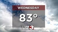
The chance for showers and storms will continue throughout the day Wednesday. Much like Tuesday, the best chance for activity will be through southeast Missouri. However, a stray shower or two will be possible in southern Illinois. It will not be a washout. High temperatures will stay below average, only rising into the low 80s.
Better areawide storm chances will arrive Thursday. The best chance looks to be Thursday evening and Friday morning. With this round, isolated stronger storms can't be ruled out. Gusty winds, lighting and heavy rain will be the main threats .
It will also be quite a bit warmer both Thursday and Friday. High temperatures will climb back up near 90 degrees. A front will bring back milder weather by the weekend.