

WSIL(Carterville, IL)-- We are already starting to see a few isolated to scattered showers work their way in from the west. Showers and rain will become more widespread as we go through the afternoon and evening.
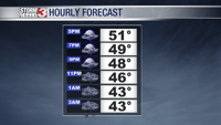
By 7:00PM, we are tracking temperatures that will be in the upper 40s with a south wind sustained at 7 miles per hour with gusts up to 17. Skies will be overcast across the entire area, but showers over southern Illinois will be isolated. Across the river, showers in southeastern Missouri will be more widespread.
Throughout the evening, showers will build in from west to east, and by 11:00PM, showers will become widespread. The entire region will be experiencing rainfall. Temperatures will be in the low to mid 40s. While there is the chance of a rumble of thunder, widespread thunderstorms are not expected.
However, winds overnight will be gusty, with sustained winds at 10 to 15 miles per hour with gusts up to 30.
The heaviest rain should be moving through the area between 2 and 4 AM, and be over by 7:00 or 8:00 AM tomorrow morning. Morning lows should only be in the mid 40s across the area, and skies to start the day tomorrow will be overcast.
Skies tomorrow will be overcast throughout the day. This will not inhibit temperatures from warming tomorrow afternoon, as we are tracking highs that will be in the mid to upper 50s. We Will likely remain dry tomorrow, though as few stray showers are possible. Warmer temperatures tomorrow will be attributed to southerly winds at 10 to 15 miles per hour, with gusts up to 25.
For the weekend, we are tracking highs in the mid 50s, with partly cloudy skies, though more clouds are possible on Saturday. We should remain mostly dry before our next system enters the region sometime on Monday and Tuesday.