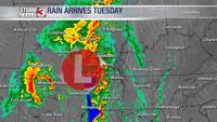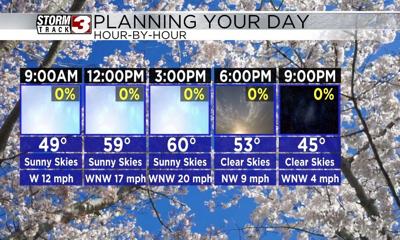


WSIL(Carterville, Ill.) -- This morning, we are tracking temperatures that are a little colder than where they were this time 24 hours ago, mainly in the low to mid 40s. We are seeing mostly clear skies across the region this morning, with winds out of the northwest at 10 to 15 miles per hour.
Today, you can expect to see clear and sunny skies all day. Temperatures will be in the lower 50s by the time we make it to the midday hours, and highs will be in the upper 50s to lower 60s. Winds today will be persistent at 15 to 20 miles per hour, out of the west-northwest. Gusts could be as high as 25 to 35 miles per hour.
Overnight, we are tracking skies that will be mostly clear. Tomorrow, we will see sunny skies once again last all day. Temperatures tomorrow will be in the upper 30s to lower 40s for morning lows, and highs will be in the upper 60s to near 70 for most spots. A warm front will lift northward tomorrow during the morning. Behind it, winds will be gusty, due to competing air masses. Winds will be sustained at 15 to 25 miles per hour, out of the southwest, with gusts potentially as high as 40 miles per hour.
A cold front will push through the area in the evening, and a few clouds are possible along with it, but no rain is expected. This cold front will cause temperatures to be on the chilly side for the weekend, with highs only expected to be in the mid to upper 40s both days. But, a warmer and more active pattern is expected for early next week.