CARTERVILLE (WSIL) �� Quiet and seasonally mild weather will continue to hold on Thursday and Friday.
A pair of weak disturbances will bring a few rain showers to parts of the region Friday night and then again on Saturday morning.
All eyes are on the end of the weekend into the early part of next week. There’s potential for winter weather to impact the region, but there’s still a lot of uncertainties regarding the track of this system.
Snow is expected to spread into Southeast Missouri Sunday afternoon and then shift eastward into Southern Illinois Sunday evening.
The biggest impacts may come Sunday night with temperatures expected near or just below freezing and light to moderate snow falling.
As the main system draws closer, precipitation is expected to increase Monday. The question will be the track and what kind of precipitation falls. Models have been trending slightly warmer on Monday which may mean a quicker change over to rain or freezing rain.
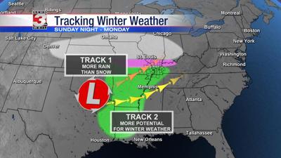
The two scenarios:
Track #1: Northern Track �� A northern track would switch snow over to rain quickly on Monday resulting in much lesser impacts.
Track #2: Southern Track �� If the system passes farther to the south, snow may change to sleet or freezing rain and impacts would be higher.
Meteorologist Nick Hausen will be tracking this system through the end of the week. We’ve got YOU covered!