CARTERVILLE, Ill. (WSIL) -- A day full of sunshine and dry conditions to show respects to those who fought to protect on this Veterans Day.

Saturday: Temperatures, cool into the upper 50's and lower 60's will dip back into the mid and upper 30's. Partly cloudy conditions will grow into the evening hours. Winds from the NE 5-10mph.
Aurora Forecast: A G2 level storm is expected from a solar flare from the sun. This occurred on November 9th. This means the northern lights or the aurora borealis may peak through across a good portion of the United States this evening and into the very early morning hours of Sunday. You can find more details on the northern lights and the forecast by going to
Solar flares can impart technology at certain levels, in this case, no major impacts are expected.

TO VIEW:
Time: As the sun is setting tonight and through 2am Sunday.
Find the darkest spot in the sky, look north and grab your camera. You will not see this with your actual eyes but rather with long exposure settings on your phone or your camera.
Cloud cover is expected to increase across the region this evening and could hinder your chance at seeing them. Even a few partly cloudy areas may allow you to see a glimpse at them.

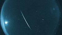
(Photo credit: Matthew Lawler -April, 2023 Northern Lights, Mt. Vernon, IL)
What your camera will see: Pink, green or even purple hues. If the solar storm is strong enough, you may even notice what is called pillars. This is where it looks like the colors stack and shoot upwards in a vertical fashion.
Sunday: Morning lows into the mid and upper 30's with afternoon highs rising into the upper 50's and lower 60's. A few passing clouds into the morning hours with beautiful sunshine in the afternoon. Clouds will roll in by the late evening hours as we go into Monday. Winds from the N 5-10mph.
Monday: Morning lows into the mid and upper 30's with afternoon highs rising into the lower to mid 60's. Mostly cloudy with a few peaks of sun possible. Winds from the N 5-10mph.

Staying dry through the week but it does appear possible to see a few chances of drizzle through the midweek. Our best shot at rain looks to be next Friday.
A lot can change even in a does worth of time when it comes to the weather. You can stay ahead of those changes by downloading the Storm Track 3 App. It's FREE on Google Play and the Apple App Store.