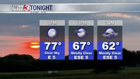


CARTERVILLE, Ill. (WSIL) -- A pleasant start to the official start of fall as temperatures jump above average into the mid 80's!

Saturday evening: Calm conditions set in with temperatures dipping slowly back into the lower to mid 60's. A few spotty showers may sneak into the SEMO region late tonight. Winds from the ESE 5-10mph.

Sunday: Morning lows into the lower to mid 60's with afternoon highs forecast to reach the lower to mid 80's. Mostly cloudy with a few peaks of sun across the region. Isolated to scattered showers and storms will arrive into southeastern Missouri and move into the region by early morning hours, diminishing through the early afternoon. A few pop-up storms may form by the late afternoon ahead of our next slow-moving system. There is some question in whether or not we could see a few storms become strong to severe. This threat would be into the late evening hours Sunday with winds being the main threat. At this time, the SPC does not have our region outlined for any severe potential, but it's not terribly far away from SEMO's doorstep, either.
Monday: Morning lows into the lower to mid 60's with afternoon highs on the slightly cooler side, into the upper 70's and lower 80's. Mostly cloudy with a few spots of isolated showers.

More rounds of isolated to scattered showers and storms will be possible through the week. As the forecast changes frequently, download the Storm Track 3 App. It's FREE on the Google Play and the Apple App Store.