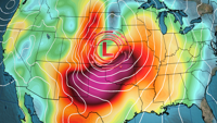


CARTERVILLE, Ill. (WSIL) -- A slightly warmer afternoon as low exits the region.��
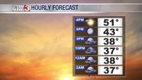
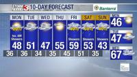
Sunday evening: Temperatures dipping from the lower and mid 50's back to the upper 30's and lower 40's. A few isolated showers may be possible into the late evening hours, but mostly staying dry.

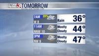
Monday: Morning lows into the upper 30's and lower 40's with afternoon highs not rising much into the mid 40's. A few isolated showers into the early morning hours. Mostly cloudy with a few peaks of sun by the late afternoon. Winds from the NNW 10-15mph with gusts up to 20mph at times.��
Tuesday: Morning lows into the mid and upper 30's with afternoon highs rising into the mid and upper 40's. Isolated showers possible maybe an isolated mix to the northern most counties of southern Illinois. Slight clearing later into the afternoon. Winds from the NW 10-15mph with gusts up to 25mph at times.��
Looking further into the work week, we stay fairly dry up until late Friday when it appears our next system could be bringing in more rain chances.��

With that system not even being formed and far out into the forecast, stay ahead of your plans and download the Storm Track 3 App. It's FREE on Google Play and the Apple App Store. There, you'll stay ahead of the latest forecast changes and track the radar as precipitation falls.��