


WSIL -- Cool, breezy, and cloudy to start the week as temperatures will remain around 10º below average for late May.

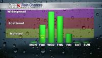
Dry weather is likely to stick around through Tuesday, but as a slow moving system tracks out of the Plains into the central U.S. Tuesday night, rain is expected to return.
Showers and storms will move in from the west and southwest Tuesday night. Pockets of heavy rain along with thunder & lightning are expected. Some of the heaviest rain may occur Wednesday morning.
Wednesday will be a wet day and showers are likely to stick around through Thursday. Rainfall amounts will range from 1-1.5" along the I-64 corridor to more than 2" in the Missouri Bootheel.

Rain will end as the weekend draws closer. As rain ends, temperatures soar, back into the mid 80s by Memorial Day.