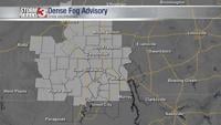


WSIL -- A Dense Fog Advisory is in effect for southern Illinois, western Kentucky, and southeast Missouri this morning as visibility has dropped below a half mile in some locations.

By mid-morning, the fog will mix out as temperatures begin to rise quickly. A weak cold front will move in from the north switching winds to the northwest. Near this boundary, we could see a few hit and miss showers and storms develop during the heat of the day. Pockets of brief heavy rain, lightning, and gusty winds will be the main threats.

Tonight, storm chances wane quickly after sunset.
There's some uncertainty to how many storms will develop Wednesday, but a complex of storms could move into the region first thing Wednesday morning. More scattered storms then may redevelop during the afternoon.

As the front moves back south, Thursday will be a dry day with a little sunshine and temperatures running around 80.
Another round of rain is possible Friday.