


WSIL -- More clouds around this morning moving in from the north and northeast with temperatures in the low to mid 60s.
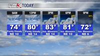
Humidity levels will be slightly lower this afternoon as some drier air gets pulled in from the northeast. Clouds will likely help keep temperatures down with highs today in the lower 80s.

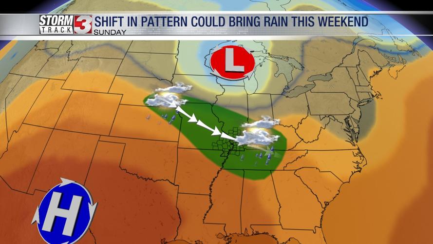
The pattern begins to change over the next few days as a large heat dome expands across Texas and the southern Plains. By Saturday, temperatures will zoom up into the lower 90s.
On the northeast side of the heat dome, small disturbances will track through the Midwest. This will likely lead to an increased chance for showers and thunderstorms. The first round of storms is possible Sunday morning, but will likely be weakening as it arrives into our region.
Temperatures by Sunday afternoon will warm into the low to mid 90s and high humidity will push the heat indices into the upper 90s and lower 100s.

Storms may redevelop Sunday afternoon and evening as another disturbance tracks in from the northeast. These storms could produce very heavy rain, lightning, and strong winds.
Storms will quickly dive to the south Sunday night as a weak cold front moves in from the north.
Temperatures will cool back a few degrees into the upper 80s by Monday and Tuesday.


