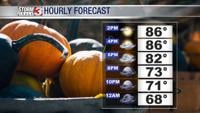


CARTERVILLE, Ill. (WSIL) -- Temperatures into the mid and upper 80's this afternoon eventually cooling us back down into beautiful bonfire weather!
Evening lows will dip back into the mid and upper 60's. Clear conditions becoming mostly cloudy through the late evening with a slight breeze from the SSE 5-10mph.
Wednesday: Morning lows into the mid and upper 60's with afternoon highs rising into the mid 80's. Scattered showers will begin in southeastern Missouri by the early afternoon. Shower and storm activity will pick up by the late afternoon and evening hours as it moves NE into the rest of the region. Mostly cloudy with a few peaks of sun through the early morning hours. Winds from the S will pick up 10-15mph and gust up to 20mph at times.
Into the overnight hours into early Thursday more showers and storms will begin to move through the region. A strong cold front will push through with winds gusting up to 25mph or greater. Though no severe storms are expected, a few damaging winds could occur with the cold front. Heavy rain and minor flooding could be another potential hazard, especially as the region grows into a worsening drought. This can make for soil to quickly become muddy and flow over roadways.

After the midweek, looking into the late week and the weekend the cold front will move out and bring in cool and dry air. We are looking at the weekend morning lows into the lower to mid 40's with afternoon highs into the lower to mid 60's. It will be quite the change that fall-lovers have been hoping for as we look to start the second official start of October.