

WSIL -- Patchy fog is possible this morning, especially in low-lying and rural areas.
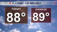
Once the fog mixes out, Monday will be a beautiful day for mid-July with humidity levels below seasonal normals. Temperatures will be in the upper 80s.
Tuesday will remain a decent day, but temperatures start to get a little warmer with highs in the lower 90s.
The mugginess quickly returns Wednesday as a warm front lifts northward. The attention will turn to the chance for storms by Wednesday afternoon and evening. There is a lot of uncertainty regarding the timing and the location of storms, but a large complex of storms moving in from the northwest will be possible.
The Storm Prediction Center has outlined most of our region in a Level 2 (out of 5), "Slight Risk" for severe storms Wednesday.
The active pattern is likely to continue into Thursday and Friday. Once again, timing and location is still uncertain, but stay tuned as we hone in on the finer details as we get closer.