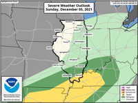


WSIL -- Scattered showers & isolated storms remain possible the rest of the afternoon, but the main focus is on the potential for strong storms Sunday night.
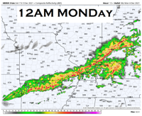
Storms are expected to develop and become widespread tonight after 8 p.m. as a strong cold front approaching from the northwest.

Once storms fire, they are likely to develop rapidly and some will have the potential for strong winds and possibly a brief spin up tornado or two.
While the threat will begin in southern Illinois and southeast Missouri between 8 p.m. and 1 a.m., overnight, the line of storms will track southeast into western Kentucky and the Missouri Bootheel.
The storm threat will exit by 4 a.m. for the our entire region and much colder air will filter in on Monday.
In fact, a system could bring the first snowflakes of the season by Tuesday evening.
The Storm Track 3 team has you covered Sunday night! Stay tuned for updates on-air and online!