


CARTERVILLE, Ill. (WSIL) -- Snow began around midnight and not much is sticking!
A few lingering rain and snow showers will be possible through the morning. We are looking to catch a break in the precipitation as we go into Monday!
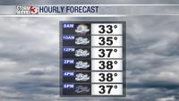
Sunday: Areas of fog and mist will be likely through the late morning hours. Rain and snow showers are expected to last into the evening hours. Not accumulating much. High: 37 Low:33.
Monday: Enjoy the break in the precipitation today. Mostly cloudy to start with some clearing possible in the late afternoon. High: Low:
Tuesday: Clouds will move into the region. Rain showers will start into southeastern Missouri and bring more rain to snow chances by Wednesday morning. High:44. Low: 29.


Going into Wednesday, there's some questions on our next rain-to-snow-maker. A shift in any direction could mean the difference in what areas see more snow than rain and vice versa.

Download the Storm Track 3 App to stay up to date with the latest changes for your region.