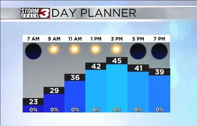


WSIL(Carterville, Ill.) -- This morning most of us are waking up to downright chilly temperatures, with most locations reporting temperatures in the lower to mid 20s. Skies are mostly clear, and winds are mostly calm.
Temperatures as we go through the day will linger in the mid 20s through the morning, but should reach the upper 30s by midday. Highs areawide will vary quite a bit. We are tracking a warm front that will move through southwest to northeast, and eventually stall out around our northern counties. Highs in our southern counties today could reach the lower 50s, while highs in southern Illinois will likely reach the mid 40s.
Skies all day today will be mostly sunny, but, once the warm front passes, skies will turn mostly cloudy overnight and overcast tomorrow, especially during the forts half of the day. Morning lows tomorrow will be in the lower 30s, around the freezing mark in Southern Illinois, but a little warmer further south. Highs area wide will be in the upper 40s and lower 50s. A few breaks are possible in the cloud cover tomorrow afternoon, and this will certainly help things warm up.
Warmer weather will stick around for the weekend with highs in the mid 50s expected on both Saturday and Sunday. Warmer weather will set the stage for widespread showers on Saturday. Rain showers will move in during the morning hours, and last through the afternoon. A few isolated showers are possible early Sunday morning in the pre-dawn hours. Otherwise, we should see mostly dry conditions. But, we are monitoring another disturbance that could bring scattered to widespread rainfall Monday. When all is set and done, we could see two to three inches of rainfall on average.