

WSIL(Carterville, Ill.) -- This morning, we are tracking a couple of isolated showers that are lingering across southern Illinois this morning, with temperatures that are in the low to mid 50s. This is the warmest temperatures will get over the next week to 10 days.
Morning Forecast December 31st, 2024
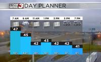
A cold front will push through the region alter this morning, and temperatures will be on the decline through the entire day. Temperatures will be in the mid 40s by 10AM and into the lower 40s by 1 or 2PM. Temperatures will be in the upper 30s by 8 or 9 this evening. Winds today will be gusty, and for this, there is a wind advisory for most of the area from 8AM through 5PM. You can expect to see winds sustained at 15 to 15 miles per hour, gusting 40 to 45 miles per hour.
Skies today will be overcast, and you can expect to see shower chances decrease one the cold front passes. However, as few showers or snow flurries behind the front cannot entirely be ruled out.
For New Year's Eve, we will see see mostly cloudy skies with temperatures that will be in the lower to mid 30s. Winds may make it feel colder, potentially in the lower to mid 20s.
Morning lows tomorrow will be in the upper 20s and lower 30s, with partly cloudy skies. High temperatures will likely reach the upper 30s, and cloud cover will be on the decrease for most of the afternoon. Temperatures will continue to be chilly for Thursday, with highs expected to reach the lower 40s.
We are tracking another cold front that will push through on Friday. This will bring a couple of chances of isolated snow showers to the region in the morning, but no significant accumulations are expected. High will be in the mid 30s for Friday, and temperatures for the weekend will hover around the freezing mark for highs.
We are tracking the potential for an active weekend as a system pushes in from the southwest. Depending on the track, we are monitoring the potential for either a winter storm, or heavy rainfall.