

WSIL(Carterville, Ill.)-- This morning, most of us are waking up to a few scattered showers and storms, especially in our southern and westernmost counties. In addition to the showers, we are also tracking morning lows in the low to mid 60s.
As we go through the rest of the day we will see morning rain showers track out of the region through much of the morning, and we will see a lot of dry time through mid morning and early afternoon hours. But, this evening, we will see a few isolated storms develop with the heating of the day. No severe weather is expected, and storms will dissipate with the loss of daylight.
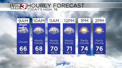
Temperatures will be in the low 70s through 9AM and into the upper 70s by noon. Highs today will be in the upper 70s and lower 80s, with partly cloudy skies this afternoon.
We will see partly cloudy skies tomorrow through most of the day. We should be dry through most of the day tomorrow with lows in the mid 60s and highs in the upper 70s and low 80s.
As we get into the late afternoon and evening tomorrow, we will see scattered showers and thunderstorms, and one or two could be stronger, but the risk overall is low.
Better storm chances will return for Sunday and early next week.