

WSIL(Carterville, Ill)-- This morning, most of us in southern Illinois are waking up to mostly clear skies and temperatures in the upper 60s with mostly clear skies. However, our southern counties are waking up to temperatures in the mid 70s with mostly cloudy skies. We are also seeing a few isolated showers in our southern counties this morning.
Through the first half of the day, before 1PM, we will see isolated shower and storm chances likely stay further south in the bootheel of Missouri and northwestern Tennessee.
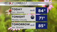
Through the afternoon and evening hours shower and thunderstorm chances will become more scattered with the heating of the day. Not everyone will see showers and storms. However the chance of pop us showers and storms is higher today than it was yesterday.
Shower chances will decrease after the sun sets later this evening. Once again no severe weather is expected.
Isolated to scattered pop up showers and storms are possible every day this week.
Highs today will be in the mid 80s. Highs for the remainder of the week will be close to normal or slightly below normal for this time of year. Next week, we should see highs return to the 90s.