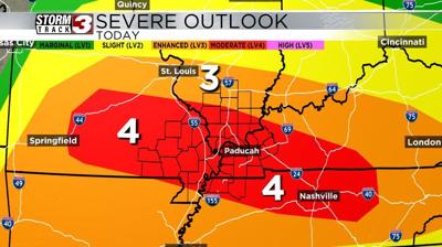
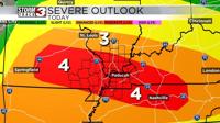


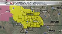


CARTERVILLE, Ill. -- There is a level 4 out of 5 severe weather risk for most of the area; we have not had a level 4 out of 5 severe weather risk since March of 2023. We will likely see a significant severe weather event today across much of our area as we have several rounds of strong to severe storms that will last from mid-morning through the late evening hours.
Round 1 will move in around late morning to early afternoon. During this first round, we will see supercell-type thunderstorms capable of producing damaging wind, large hail, and tornadoes (a few of which could be on the strongside). Round 1 should be over by mid afternoon.
Round 2 will come on the heels of the first, and move in late this afternoon and evening. This round will be more of a linear storm complex capable of producing damaging winds in excess of 70 miles per hour, and the chance of a few tornadoes with some imbedded supercells. This line will track from west to east across the area and exit the region late this evening.
It is possible that we will see a third round of strong to severe thunderstorms move through as the cold front passes through the area, and it would be similar to round 2, though possibly less strong.
The severe threat will end once the cold front passes late tonight, ad stabilizes the atmosphere.
In addition to the storm threat, we could see 2 to 3 inches of rain with locally higher amounts possible. For this reason, there is a Flood Watch trough early tomorrow morning. Right now, only western Kentucky is included, but this may change.