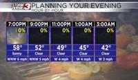


WSIL(Carterville, Ill.) -- This evening, we are tracking temperatures that are largely in the low to mid 60s across most of the area, with a few isolated spots in the upper 60s to lower 70s across far southern Kentucky and southeastern Missouri.
For the rest of the evening, we are going to see temperatures in the lower 60s and upper 50s through 7PM, still with mostly sunny skies. Clear skies will persist in the evening and overnight hours. This, combined with mostly calm winds, will help temperatures cool into the lower 40s for morning lows tomorrow.
Tomorrow, we will see lots of sunshine, especially in the first half of the day. But, cloud cover will return into the second half of the day, with skies expected to be completely overcast by 5 PM. Winds tomorrow will turn more southeasterly, and be sustained at 10 to 20 miles per hour. Temperatures tomorrow will warm into the low to mid 60s for highs.
A few showers and storms are expected tomorrow evening, after 6PM through the overnight hours, but nothing severe is expected. Better rain and storms chances will persist through the second half of the week through the weekend. We may have to watch the potential for strong to severe storms Saturday.