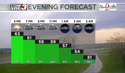


WSIL(Carterville, Ill.) -- This evening, we are tracking a mix of sun and clouds, with more sunshine further south. Temperatures this evening are in the mid to upper 60s, with the warmest temperatures being reported further south and west across Southeastern Missouri.
For the rest of the evening, we are tracking temperatures that will be in the mid to upper 50s throuhg most of the evening. A few isolated showers are possible north of State Route 13 between 6 PM and 11 PM. However, they are expected to be light, and most locations, generally, will remain dry. Overnight, temperatures will drop into the upper 40s to lower 50s for tomorrow morning's low temperatures.
Tomorrow morning, skies will be mostly sunny, and there will be lots of sunshine through the first half of the day. This will help temperatures reach the upper 60s to lower 70s for high temperatures tomorrow afternoon. A cold front is expected to move in during the early afternoon hours tomorrow. Along it, we could see scattered showers and thunderstorms form. One or two these could be on the strong side, but the severe weather risk is EXTREMELY low. We will not see anything near the level of what we have seen.
Once the cold front moves through the area, temperatures will cool into the mid 50s for highs on Friday and Saturday. But, abundant sunshine can be expected. Warmer temperatures are expected for Sunday.