

WSIL(Carterville, Ill.) -- This evening, we are tracking temperatures that are in the mid to upper 60s across most of the area, with southeasterly winds at 10 to 15 miles per hour for most locations. This evening we are tracking mostly calm and mild conditions with temperatures that will be in the mid to upper 50s. Winds tomorrow will be very strong, out of the south and west at 20 to 30 miles per hour, gusting as high as 45 to 50 miles per hour. For this, there is a wind advisory in place from 7 AM - 12 AM Thursday Morning.����
Our main concern in the forecast is for the potential for widespread significant severe weather tomorrow, and then the potential for significant and historic flash flooding Wednesday through Sunday.��
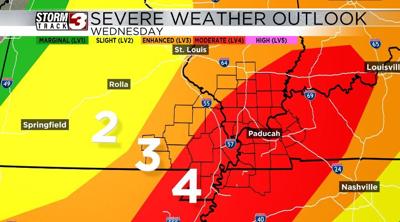
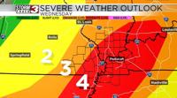
Severe weather Tomorrow:
We are currently under a moderate level 4 risk for severe weather on Wednesday, with storms expected between 2 PM �� 12 AM, broadly.�� The first supercell thunderstorms may develop in southeastern Missouri between 2��4 PM, moving northeast into southern Illinois by early evening. They are expected to rapidly intensify, as they track into southern Illinois, and could take on the form of a broken line of supercell thunderstorms. They will cross into western Kentucky sometime between 6 and 8 PM, and are expected to region entirely by late Wednesday evening into early Thursday morning. These storms could bring all modes of severe weather, including Tornadoes (some potentially strong), Large hail, and Damaging winds, especially if storms form into a line along the advancing cold front.��
There is a lower but still possible risk of additional severe weather on Thursday, depending on how quickly the Wednesday night storms move out. Based on current projections, this event could be more significant than Sunday’s storms and may rival the March 14th tornado outbreak.
Major Flooding Risk �� Potentially Historic Rainfall
The same cold front driving Wednesday’s storms is expected to stall near the Illinois/Kentucky/Tennessee state line, leading to multiple rounds of heavy rain through Sunday morning. Current forecasts indicate 6��10 inches of widespread rainfall, with some areas potentially exceeding 12 inches or more. This could result in historic and life-threatening flash flooding across the region. For this, there is a Flood Watch in place from Wednesday through Sunday morning, specifically for up to a foot of rainfall. Widespread rain is expected Wednesday through Sunday Morning��
��