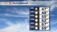


WSIL(Carterville, Ill.)-- This morning, there is a bit of of patchy fog, especially across southern Illinois where dew point temperatures and air temperatures are closely aligning.Temperatures this morning are mostly in the upper 40s and lower 50s.
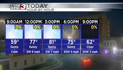
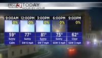
Patchy fog will not last too long and we should see it burn off once the sun rises. Today, sunny skies will last all day today. Temperature will warm into the mid to upper 70s by the lunchtime hour, and we should see highs today in the lower to mid 80s once again.
Once again, Humidity levels will remain pleasant as dew points should remain near 50 this afternoon. Clear skies are expected this evening through the overnight hours tonight. This will help temperatures for evening football plans to cool into the mid 60s.
Tomorrow, morning lows should drop into the the upper 40s and lower 50s. Highs tomorrow will be in the lower to mid 80s for most of us. Areas north and west will see the warmest temperatures, with a few spots potentially reaching the upper 80s. Skies tomorrow will be partly cloudy for most of the day tomorrow, but we will see less cloud cover in the evening.
Partly cloudy skies and warmer temperatures in the lower 80s will stick around through Sunday, but a cold front will push through late this weekend, and we will see much cooler highs early next week. Highs on Monday will be in the low to mid 60s, and in the upper 50s to near 60 Tuesday. Morning lows early next week will be in the mid 30s, so we could see our first frost of the season.