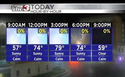


WSIL(Carterville, Ill.)-- This morning, we are tracking a little bit of patchy fog, especially close to the Mississippi and Ohio Rivers. However, patchy fog will not last too long. Sunny skies will help any fog burn off quickly.
Today, you can expect to see sunny skies last all day today. Temperature will warm into the upper 60s by the lunchtime hour, and we should see highs today in the mid to upper 70s once again. A few areas today could certainly see the the lower 80s for high temperatures.
Humidity levels will remain fairly mild dew points only in the mid 40s expected this afternoon. Clear skies are expected overnight tonight, and we will wake up tomorrow morning in the upper 40s and lower 50s.
Highs tomorrow will be in the upper 70s and lower 80s for most of us. This weekend, we will see a little more cloud cover with temperatures in the mid 80s Saturday and lower 80s Sunday.
A cold front will push through late this weekend, and we will see much cooler highs early next week. Highs on Monday will be in the low to mid 60s, and in the upper 50s Tuesday.