

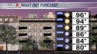


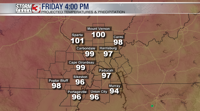


WSIL(Carterville, IL)-- Temperatures today warmed into the upper 90s today with most of the region experiencing air temperatures of 95-99 degrees. The humidity did not help matters with the heat index reaching the low to mid 100s this afternoon.

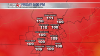
We are expecting things to get even hotter tomorrow with highs around the 100 degree mark. Not everyone will see 100 degree temperatures, but where humidity values are lower, we could see parts of the region reach and pass the 100 degree mark.

Regardless of actual air temperature, heat index values tomorrow will be around 105-110.

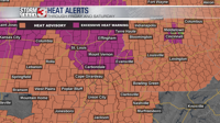
For this reason, the weather service has placed out entire region under various heat alerts. A heat advisory is in effect for areas across south eastern Missouri, far southern Illinois, and western Kentucky. Further towards the north, there is an excessive heat warning in effect. Both are set to expire Saturday 7PM.
Looking ahead to this weekend, the 90s will be here to stay with highs in the upper 90s on Saturday, and low to mid 90s on Sunday. We are also tracking an isolated chance of showers on Saturday. However, this will continue to be mostly dry across the region through the weekend.
For next week, we will cool off slightly on Monday, but the mid to upper 90s are expected tp return by the middle of next week, with minimal rainfall expected at this time.