


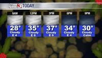


WSIL -- Plan a little extra time to scrape off the windshield this morning if you park outside, there is a lot frost this morning.

The calm before the storm. Monday, Tuesday, and Wednesday will have a lot of similarities with cloudy skies and afternoon temperatures in the upper 30s and lower 40s.
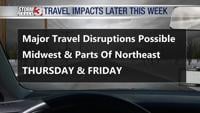
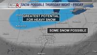
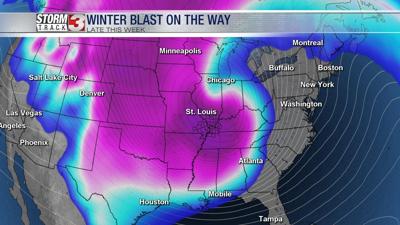
On Thursday, a storm system will track out of the Plains into the Midwest. Finally, the track of this system is coming into focus.
Right now, it appears temperatures will climb into the lower 40s in many locations Thursday afternoon. As precipitation begins, it will start as primarily light rain.
Thursday night, an Arctic cold front will arrive. This will likely lead to a change from rain to snow. Snow may linger into early Friday morning before coming to an end. There is still uncertainty regarding the amount of snow that will actually fall. At this point, we are not expect a big snow in our region.

As temperatures plummet, it will not take much snow to cause big travel problems.

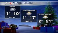
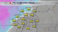
By Friday morning, temperatures will drop into the lower single digits. Wind gusts of 35-45 miles per hour are possible. This will push wind chills into dangerous territory with reading -15 to -20º possible.

Wind chills will remain below zero during the day Friday.

Temperatures will remain below freezing through the weekend.