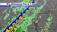


CARTERVILLE Ill. (WSIL) -- Winds have turned out of the northwest behind the cold front. This is going to usher in much cooler air overnight. Any lingering showers will move east of the area and clouds will begin to break up as well. This will allow temperatures to drop down near 30 degrees by Tuesday morning. Bundle up!
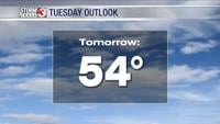
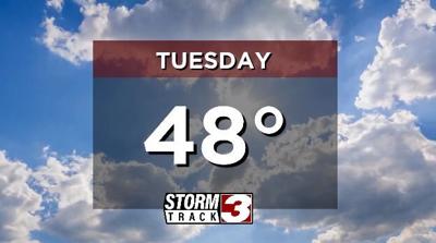
Winds will be calmer Tuesday and the sunshine will return. However, it will be quite a bit cooler. High temperatures will drop back below average, topping out in the upper 40s.
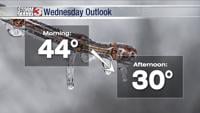
Our next system will arrive Wednesday. This will bring a chance of showers, primarily in the evening and overnight. It's looking like rain will clear very early Thursday, just in time for Thanksgiving. However, if you're traveling Wednesday, you may run into some active weather. Overall, rainfall amounts look light, under a half inch.
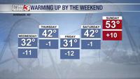
If you have any plans for Thanksgiving weekend, get ready for the cold. A blast of cold air is expected with the coldest temperatures of the season. Highs will drop into the 30s, with lows in the 20s. We may even see some flurries. Stay warm!