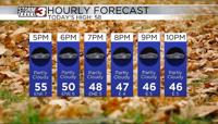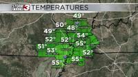


Carterville (WSIL) -- Turning out to be a lovely first day of the weekend across the area. The clouds burned up quite nicely as we progressed into the afternoon leaving most of us mostly sunny for the day. Temperatures however didn't recover as much with the northerly winds, with most of us staying in the low 50s for highs which is technically below average for this time of year.
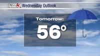
Tomorrow things change slightly. We will start to see winds shift dramatically from the south bringing in a warmer airmass. This will also lead to more clouds across the region with a mostly cloudy sky by the evening.

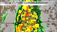
Monday our cold front finally approaches and with high pressure just to our east the pressure gradient will be quite strong across the area. This is going to lead to some very strong winds across the area all day long. Most guidance has consistent wind gusts around 40-50 mph. NWS is monitoring the potential for wind advisories or even warnings for part of the area for Monday. This will be the biggest story for Monday along with a close second being the heavy rain threat in the evening.
The cold front will be slow moving and will move in from the west around 6PM and travel its way east across our eastern areas by around 1AM. There will be plenty of heavy rain in and around the cold front with the heaviest confined along the front. Severe weather does not look to be an issue as there is little to no fuel for significant thunderstorms. However, there will still be some imbedded thunder along with rains that could cause localized flooding especially along flood prone roadways. This rain combined with the strong winds can cause some trees and tree limbs to fall and even bring along power outages across the region.
We will continue to monitor it all closely as the weekend continues.