

WSIL(Carterville, IL)-- This morning, we are seeing exceptionally warm, spring like temperatures, with most of us waking up to temperatures in the mid 60s!
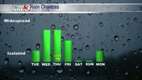
These warm temperatures are due to the passage of a warm front, which is giving us the chance of some strong to severe thunderstorms this afternoon. There is a severe thunderstorm watch currently for Perry and Jefferson Counties in southern Illinois. This watch goes until 12:00 PM this afternoon. This is not the our only chance of strong to severe weather.
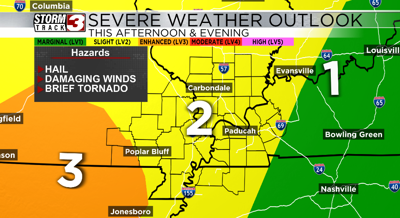
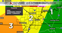
There is already a level 2 risk for our entire area and a level 3 risk around far southwestern areas of our area for this afternoon.
This afternoon, we will see a lot of dry time, and the potential for some clearing in the cloud cover. This clearing will help to destabilize the atmosphere, and help highs get into the mid to upper 70s this afternoon.
With this destabilization, we could see a few strong, isolated supercell thunderstorms capable of producing large hail, a few tornadoes, and damaging wind. The best chance of a few supercells will be in western parts of the area.
This evening, we will see a line of storms develop and track west to east. This line could produce damaging winds, hail, and a brief tornado can't be ruled out. We will see it enter our westernmost counties around 8:00 or 9:00 PM. Once the line passes, our severe weather threat will end, and we will be left with just showers and thunderstorms tomorrow morning.
Highs tomorrow will be in the mid 60s, but it will be in the overnight hours while most of us are asleep; afternoon temperatures will be in the mid 50s once the cold front passes.