
CARTERVILLE, Ill. (WSIL) -- Thunderstorms are expected to develop in the overnight hours across southeast Missouri and southern Illinois.
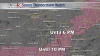
Some of these storms may become severe and there is potential for a brief tornado, large hail and damaging wind gusts between midnight and 5 a.m. Saturday morning.
For the overnight hours, we have a level 2 Slight risk for storms for portions of southern Illinois, including, Jefferson, Perry, Jackson, Franklin, Randolph and northern Hamilton counties. Also, for portions of southeast Missouri which include Perry, Bollinger, northern Cape Girardeau, Madison, Wayne and Carter counties. There's also a level 1 Marginal risk for Union, Alexander, Johnson, Pulaski, Williamson, Saline, northern Pope, southern Hamilton, Gallatin and White counties in Illinois, and Ripley, Butler, Stoddard, southern Cape Girardeau and Scott counties in Missouri.
Temps tonight will stay steady in the lower to mid 70s with winds around 10 - 15 mph at times. When the rain and thunderstorms hit starting overnight, temps will dip down into the mid 60s.
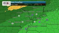
Waking up on Saturday morning, we will see temps in the mid 60s with light winds coming out of the south southwest. Rain chances will continue throughout the day with most of the activity in the morning hours. Temperatures will also stay steady, only climbing a couple degrees by the afternoon hours.
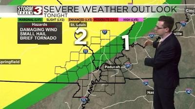
Sunday, another threat for severe storms for our area. The severe storms look to be towards the evening hours. Temps on Sunday will reach the mid to high 70s in spots.
A level 2 Slight risk for severe weather has been issued for most of southeast Missouri, with the exception of Mississippi County. The level 2 risk is also for Randolph County and the western portion of Jackson County.
A level 1 Marginal risk is in effect for the rest of the region with the exception of Calloway, Crittenden, Caldwell and Lyon counties in Kentucky.
For Monday, chances for thunderstorms and rain will continue in the morning hours. Temps will be a bit cooler but not much, mainly holding in the 60s for throughout the day.