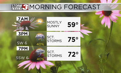


WSIL(Carterville, Ill.)-- This morning, most of us are waking up to some patchy fog, especially in southern Illinois and western Kentucky. Temperatures are in the upper 50s and lower 60s.
As we go through the morning hours, we will start to see the fog burn off with the sun. Out best chance of seeing any sunshine today will be in the morning hours. Temperatures through the midday hours will be in the low 70s and highs today will be in the mid to upper 70s across southern Illinois; the low to mid 80s are possible across southeastern Missouri. As we get into the afternoon hours, skies will turn mostly cloudy.
Cloudy skies are going to bring scattered to widespread showers and thunderstorms. Through the midday hours, we could see a few isolated showers across the area, but in the afternoon hours, there is more of a scattered chance of showers and thunderstorms. One or two of these storms could be on the strong to severe side, with the greatest hazards being damaging winds and small hail. Overall the risk of severe weather is low.
Overnight, more widespread rain will move in and last through much of the Friday morning commute. Widespread rain will last through the much of the day Friday, and there cold even be some imbedded thunderstorm activity; nothing severe is expected.
WHen all is set and done, we could see one to three inches of rainfall on top of what has already fallen, so localized flash flooding is a concern.
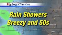
Highs tomorrow will be in the low 70s. Well above average and summer like highs are expected for the weekend and early next week.